AutoPlotter Advanced Software Price & Specifications
Usage Civil Engineering Design, Survey Data Management, Earthwork Computation
Type Survey and CAD Software Solution
Security Features USB Dongle based License Protection, User Authentication, Data Encryption Support
Language Support English, Custom Language Packs Available
Interface Type Graphical User Interface (GUI)
Compatible System Windows 10, Windows 8, Windows 7 (32/64 bit)
Capacity (Person) Single User License, Multi-user options Available
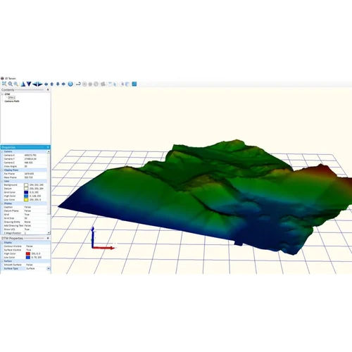
Application Land Survey Data Processing, Topographic Mapping, Road Design, Volume Calculations, GIS Data Generation
Supply Ability 100 Per Month
Delivery Time 10 Days
About AutoPlotter Advanced Software Detail
Unlock the potential of your surveying projects with AutoPlotter Advanced Software - your invincible solution for land survey data processing, topographic mapping, and road design. Grab Yours today at an unbeatable price and experience superlative integration with Total Stations and GPS data. Enjoy comprehensive file format support (DWG, DXF, CSV, LandXML, TXT), robust export options (PDF, CAD, Excel, KML), and customizable modules for road design, survey, volume calculation, and GIS. Benefit from perpetual licensing or flexible subscriptions, user authentication, USB dongle protection, and one year of free updates. Elevate your workflow with this remarkable tool, designed for civil engineering excellence!
Comprehensive Solution for Survey and Civil Engineering
AutoPlotter Advanced Software stands unmatched for both specific and general use in civil engineering projects. Designed for land survey data processing, topographic mapping, and GIS data generation, it caters to professionals seeking efficiency in data management and earthwork calculations. Whether automating survey reports or enabling advanced volume calculations, this user-friendly platform offers versatile application throughout the project lifecycle, giving you a significant advantage in workflow optimization and data accuracy.
Seamless Purchase Policy and Efficient Delivery
Place your Purchase Order with confidence for AutoPlotter Advanced Software. Once your order is received and processed, the order completion and software outlay are managed with transparency and care. Packaging details include secure offline installer kits, activation dongles, and comprehensive user documentation. Expect prompt dispatch and delivery to your designated address. Our policy ensures rapid fulfillment and your satisfaction, supporting seamless integration into your organization's operations.
FAQ's of AutoPlotter Advanced Software:
Q: How can I install AutoPlotter Advanced Software on my system?
A: AutoPlotter Advanced Software is supplied as an offline installer. After purchase, you receive the installation files and a USB dongle for license protection. Follow the comprehensive user manual for step-by-step guidance, ensuring smooth activation.
Q: What makes AutoPlotter Advanced invincible for survey and CAD applications?
A: This software integrates flawlessly with Total Stations and GPS, supports a range of file formats, and includes customizable modules for road design, survey utilities, and GIS. It automates report generation and offers advanced security, making it a superlative choice for professionals.
Q: When will I receive my software after placing an order?
A: After your Purchase Order is received and confirmed, we promptly process your order. Delivery timelines depend on your location, but we aim for swift order completion and dispatch, ensuring you receive all necessary materials quickly.
Q: Where can AutoPlotter Advanced Software be used?
A: The software is compatible with Windows 7, 8, and 10 (32/64 bit). It supports application in civil engineering, land surveying, topographic mapping, road design, volume calculations, and GIS data generation across diverse projects.
Q: What is the process for updating AutoPlotter Advanced Software?
A: Upon purchase, you receive one year of free updates. Notifications for new releases are sent via email, and updates can be installed according to the provided instructions, keeping your system up-to-date with the latest features and security patches.
Q: What are the usage benefits of customizable modules in AutoPlotter Advanced?
A: Customizable modules allow users to tailor the software to specific project needs-whether working on road design, survey utilities, or volume calculations-yielding higher productivity, minimization of repetitive tasks, and adaptable GIS functionality for diverse environments.

 GST No.07ABZFA3461F1Z6


 Our Products